Decoding the Information Manifold
A space domain awareness platform for students, researchers, and practitioners.
(Early release · Expect rough edges)
Platform Access
Sign in or create a free account to unlock FalkonEye's advanced capabilities — access planning, link budgets, coverage audits, and more.
Not for commercial use
What is FalkonEye?
FalkonEye is a space domain awareness platform developed to help students, researchers, and practitioners better understand the space ecosystem and space domain operations such as access planning, coverage audits and conjunction analysis. It is an educational and research project and is not intended for commercial or operational use.
For modeling and simulation purposes, FalkonEye aggregates data from publicly available sources — Space-Track.org, CelesTrak, FCC IBFS, and others — supplemented where necessary with AI-generated engineering estimates. Data provenance is tracked throughout so users can always see the source and confidence level of every parameter used in an analysis.*
33,000+
Tracked Objects
1,000+
Ground Assets
4
Mission Planners
8 hrs
TLE Refresh Cycle
* The developer makes no guarantees on the accuracy or currency of the data. It is sourced from public repositories and not obtained directly from satellite operators or manufacturers. Engineering estimates derived from satellite class and orbit regime archetypes are clearly labelled throughout the platform.
Capabilities
A suite of analytical tools covering typical space domain awareness and operations workflows — from orbit visualisation to link budget closure and coverage gap analysis.
Explore what's out there
Advanced Visualisations
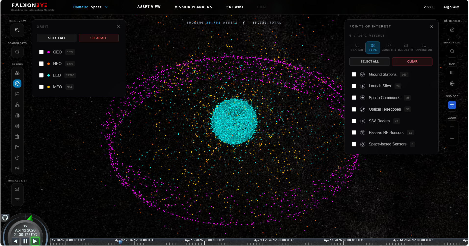
Explore 3D and 2D visualisations of over 33,000 tracked space objects — payloads, debris, and rocket bodies — with real-time and fast-time SGP4 trajectory propagation. Over 1,000 global ground assets are also available, including ground stations, SSA radars, optical telescopes, and space command facilities. A faceted search allows filtering by object type, orbit regime, country, constellation, mission type, and RF frequency band.
Learn about any asset
Space Wiki
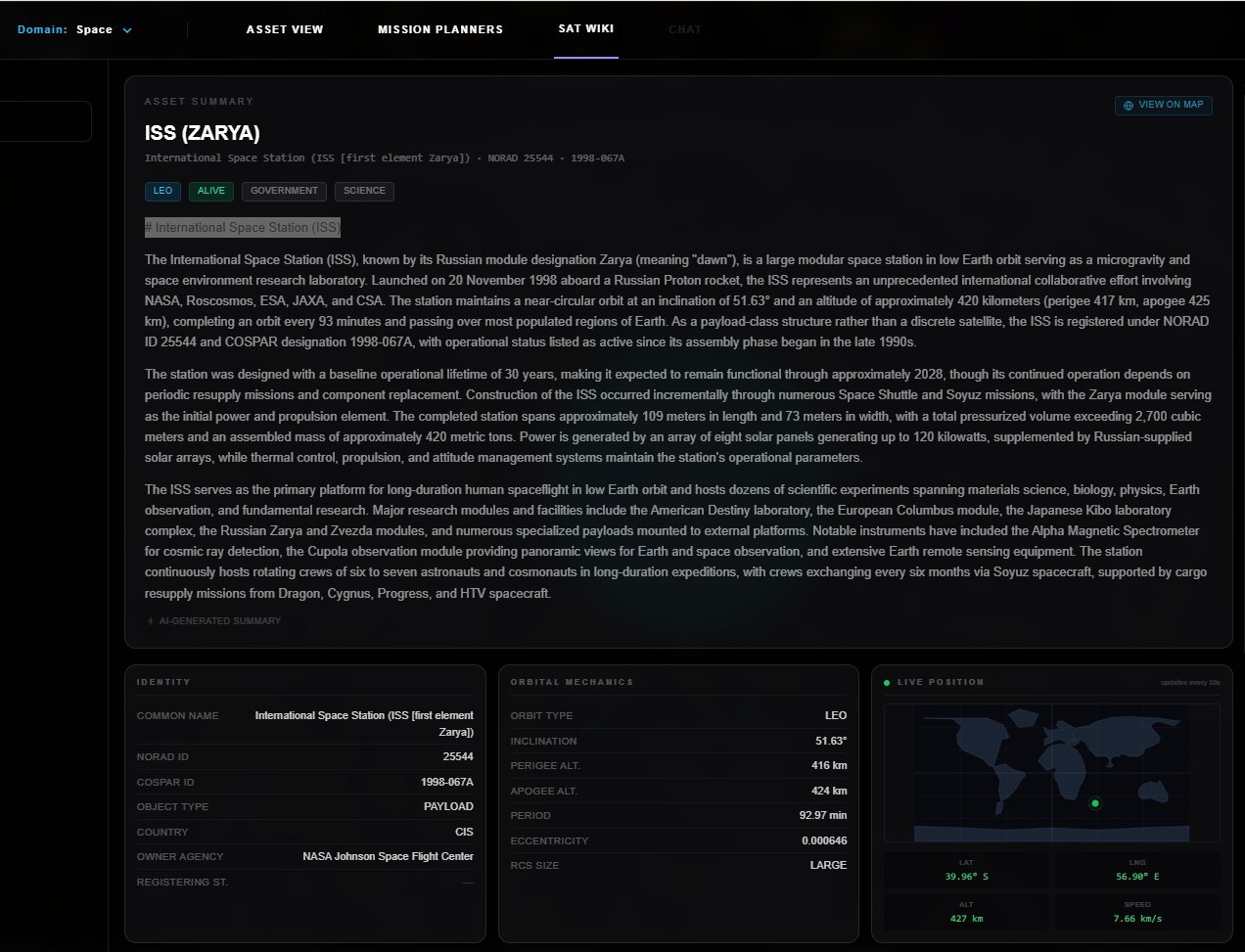
A searchable, AI-augmented wiki covering satellites and ground assets — physical characteristics, orbital parameters, mission profile, and RF capabilities including both mission payload and TT&C systems. AI-generated narrative summaries provide broader mission context. Data lineage for every parameter is shown so users can see exactly where each data point originated and how much confidence to place in it.
Who is above me?
Access Planner
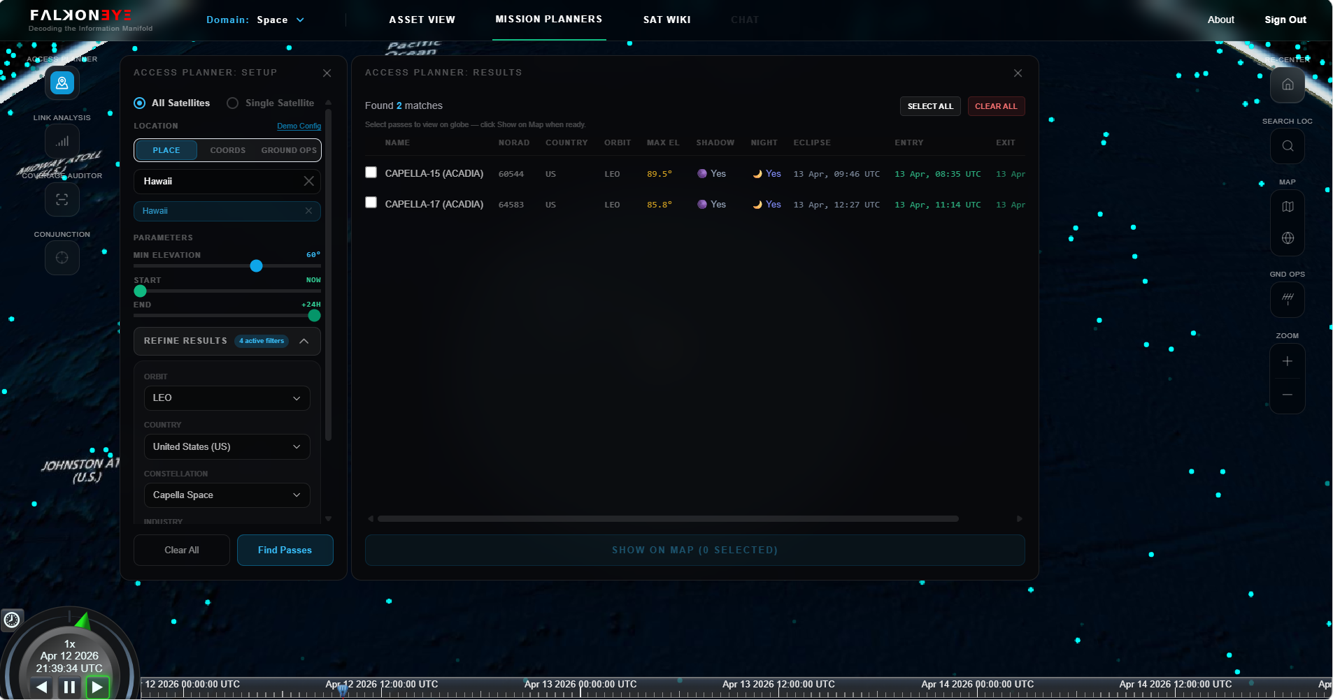
Computes and visualises which satellites will pass over a given location — specified as a latitude/longitude coordinate, city, or named ground asset — within a user-selected time window. Uses a three-stage algorithm: orbital regime filter, PostGIS spatial intersection against pre-computed ground-track corridors, and precise SGP4 pass computation. Results include AOS/LOS times, peak elevation, pass duration, and slant range. Filter by country, orbit type, constellation, and mission category.
Will you be able to hear me?
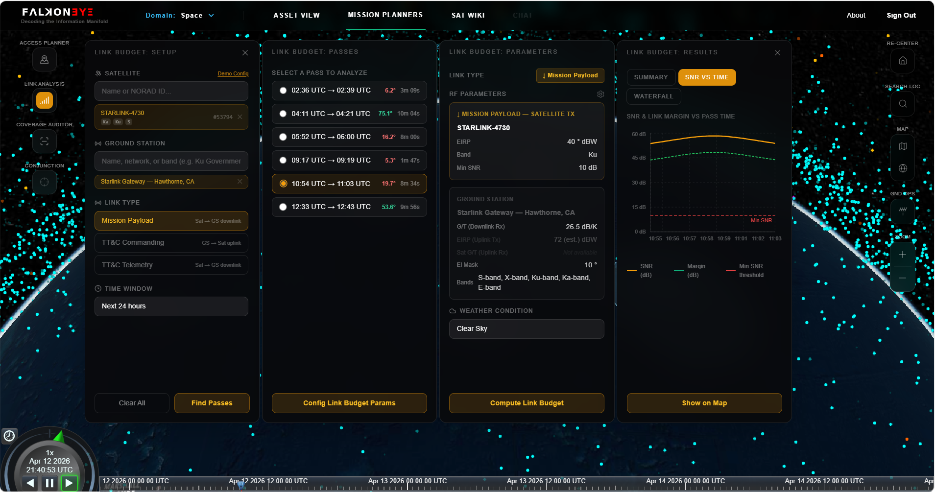
Link Budget Analyser
A medium-fidelity tool applying the Friis transmission equation across three link types: mission payload downlink, TT&C commanding (uplink), and TT&C telemetry (downlink). Inputs include satellite and ground station EIRP, G/T, frequency band, atmospheric absorption, and rain fade modelled across four weather conditions. RF parameters are clearly labelled as Published Specification or Engineering Estimate. Users can override any parameter for sensitivity analysis. Results include a link budget waterfall, margin over the pass window, and estimated throughput.
Link margin results are mathematically correct but are only as reliable as the underlying RF inputs. For most satellites, EIRP and G/T values are engineering estimates derived from satellite class and orbit regime. Treat results as indicative order-of-magnitude analysis, not operational link closure.
Where are my communication gaps?
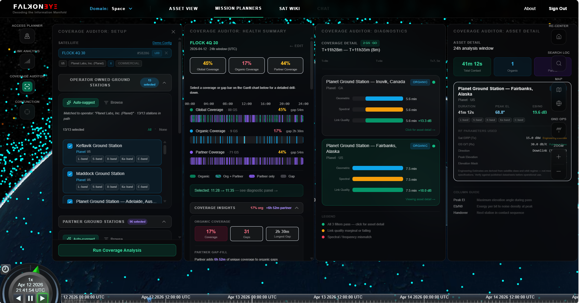
Coverage Auditor
Computes contact window coverage and communication gaps as a selected satellite orbits the Earth against a user-configured network of ground stations. Distinguishes between operator-owned (organic) and partner/commercial stations, quantifying the incremental coverage value of each tier. Analysis uses three layers: geometric pass visibility, spectral band compatibility, and link quality via the Friis equation. Results are a Gantt-style coverage timeline with root-cause gap diagnostics and full RF parameter transparency.
Are there any close approaches?
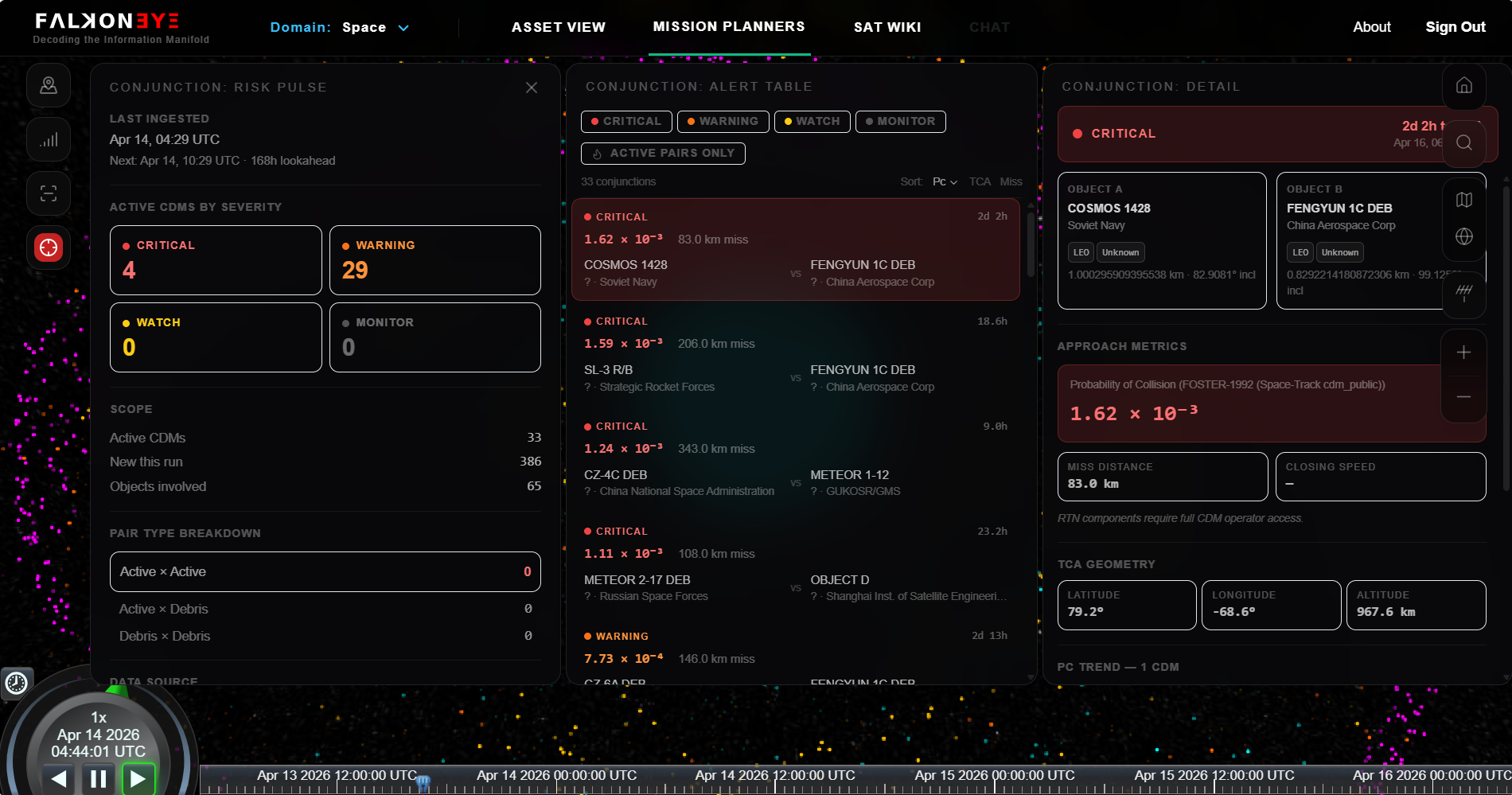
Conjunction Analysis
Ingests Conjunction Data Messages (CDMs) issued via Space-Track, providing authoritative collision probability (Pc) assessments for all tracked objects. Active conjunctions are classified by severity tier — Critical, Warning, Watch, and Monitor — based on FOSTER-1992 Pc thresholds. The alert table shows pair type, miss distance, and hours to Time of Closest Approach (TCA). Selecting any conjunction reveals the full CDM detail, Pc trend across successive radar-derived updates, and TCA geometry computed by propagating the latest available TLE. CDM data refreshes every six hours in line with the 18 SCS update cadence.